
Sluice Creek exploration: 14 km, +765 m, -765 m, 8 h 40 m
As expected, the night was peaceful, and not as cold as we feared. The brisk wind soon died down and the quiet descended. I was comfortable and stirred only a few times, quickly falling asleep again. At one point I thought I heard a small creature nibbling on something right next to the tent, and for a moment the memories of the tent damage on our Mount Assiniboine trip came back to haunt me, but I could tell it wasn’t the tent itself and I soon drifted off again.
I stirred as the day lightened, dozing until the sun lit up the tent around 7 am, and crawling out around 8 am as I heard Stephen and Colleen begin to move. I collected our food bags and cooking gear and we all met at the end of the lake again to enjoy breakfast in the morning sunshine. The wind had dropped completely and the sunlit mountain ridge ahead of us was reflected perfectly in the completely still lake, which had lost all of its colour from yesterday. It was only when the wind picked up again to riffle the surface did that bright turquoise become more obvious. “Eek!” The squeak of pikas carried across the water from the scree slopes nearest to us.


After breakfast and some truly terrible coffee in an absolutely stunningly beautiful place, we pulled together our gear, stowed our food and set off on the day’s exploration. We left our tents just after 10:30 am and followed the trail downstream to try and find a suitable spot where we could strike off through the trees to reach the Sluice Creek valley. Nothing obvious showed itself so at some point we just made the decision to turn off the trail and head into the open forest. Travel was alternately easy and treacherous – easy when brushing through grassy undergrowth between the pines but then we’d hit massive deadfall roadblocks that took quite some care and effort to negotiate. Mixed in among the bright green grass was an abundance of arnica and lupine flowers, creating a wonderfully cheerful colour palette.


It was slow going but eventually we crested the low ridge and began to descend in more open forest, the only obstacle now the sheer number of cobwebs linking every branch of every tree. We emerged from the forest onto open flats by the creek, and were treated to a clear view straight up this magnificent valley to the craggy peaks and ridges at its head. Recent rain had caused the creek to flood over these flats which were now covered in soft silt that showed a variety of deer and goat tracks. Further up the valley we found grizzly bear prints in the gravel, probably a few days old, their outlines softened by the water that had overflowed from the creek.
The going was now mostly easy as we picked our way through rocks and silt, occasionally detouring around patches of pine and scrubby bushes to avoid numerous little water-filled potholes and spongy moss. The guide book advised that we cross the creek before an obvious bend, and we followed the braided, milky creek upstream until we reached a suitable crossing point. Stephen’s exploration had led him over the creek before us without having to take off his boots, unlike us. At least we found a spot with relatively smooth rocks that wouldn’t be too hard on our feet. The creek was shallow – perhaps reaching my mid-calf – but surprisingly fast flowing, and – of course – freezing cold. I was glad it was a short crossing! We sat down on the heather to dry off our feet and pull on our boots, taking advantage of the rest to top up our energy levels.


We continued on over tussocks of heather and cottongrass, avoiding a couple of large pools in the meadows, and came back alongside the creek where the going became easier once again over rocky and bouldery flats. More evidence that the creek had recently flooded the meadows was the layer of fine pale grey silt that coated the plants and even the lower branches of some trees. We were very glad we had a better weather forecast for our trip. The meadows were rich in understated flowers such as partridgefoot and kalmia, pink, white, and yellow heathers, and some low-lying cranberries or blueberries.


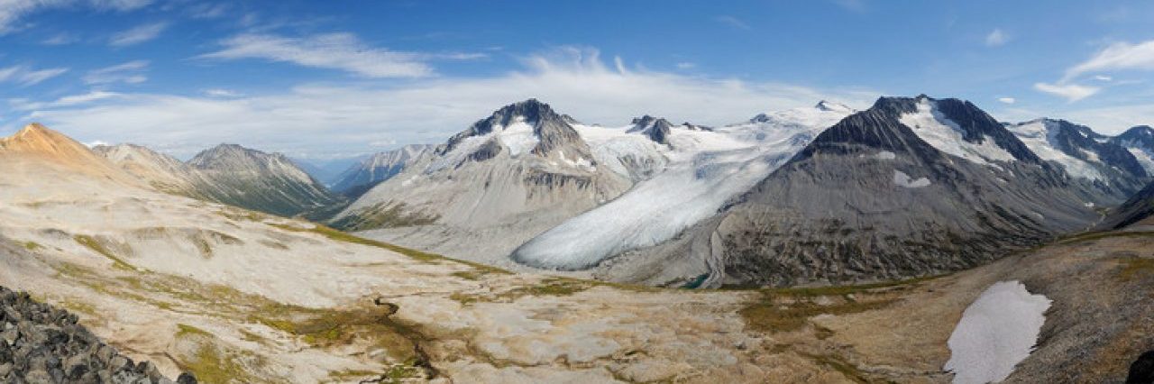
The hiking was enjoyable and navigation was easy, the route allowing us to follow the west bank of the creek, mostly on rocks but occasionally skirting trees growing right the the water’s edge. At one point we had to push through the outer branches of a small fir tree on a narrow embankment, hoping that they wouldn’t be strong enough to push us into the creek! We passed a small tumbling waterfall – more a series of cataracts than a waterfall really – and continued on upstream. Ahead of us, the towering peaks stood out against a backdrop of forbidding-looking cloud and I shivered at the cool breeze that was sinking down the valley from the glaciers above.
The way ahead was clear, and although the route on the map followed the creek, we decided to begin gaining elevation a little sooner to make the process a little less painful. To that end, we struck out on an ascending diagonal line over open slopes of heather, small trees, and scree, aiming for an obvious bench. Every step led to better views: we could now see more of the glacier at the head of the valley and took in the elevated perspective over the creek, both ahead and behind us. The thickening clouds kept the air on the cool side, especially now that we were closer to the great patches of ice clinging to the north-facing slopes, although that may have been at least partly psychological.


Inevitably, the climb became steeper and we stopped to check the map and decide on our best route. It didn’t take long to work out: the only way was up and up and we ascended on broken rocks and compacted dirt in various shades of orange, eventually reaching a small dirt rib that allowed easier (if no less steep) walking. The altitude was definitely making its presence felt on this steep climb, and we stopped frequently to catch our breath and check out the ever-expanding views. A number of white blobs further up the slope had us wondering if they were mountain goats, but they turned out to be just rocks. Had they been goats, they would have been extremely large goats…!
By now we were beginning to tire (having been on the move for over 3 hours already) and we paused for a rest and another snack break, taking a moment to soak in the scene before us: the rugged, fractured skyline of the mountains, the meandering braids of a meltwater creek birthed by a snow field and lined with bright pink fireweed, the blue ice of the glaciers contrasting with the reddish rock. A small meltwater pool caught our eyes, bright green against the rusty earth around it. Quite desolate, I suppose, and not particularly welcoming on a cool, cloudy day, but it was clearly home to something as we spotted an obvious game track over the ground below us.


While the others rested a little longer, I pushed on up the ever steepening slope to try and work out our best route. The lay of the land was such that we had no landmarks above us, just a broad, convex mountain slope that stretched ever upwards. I used the GPS to try and identify a bearing to take, and tempted the others to begin moving again. Every time I thought I’d level out onto the ridge-top, I was greeted by more slope. Plodding our way up the steep – and occasionally loose – scree was energy- and morale-sapping. Maria and I found an iron-stained group of rocks to perch on for a few minutes before continuing upwards. Behind us now we could see the whole Sluice Creek valley that we had walked as well as the thin strip of bright blue beyond the trees that was Lorna Lake. I was hoping the sun would come out to really emphasize the colour. Maybe later?


After what seemed like an age we finally came to a point where we could see where we were heading, and realized we were a little off on our bearing. The reason the slope kept on going up was because we were heading straight up a small peak along the ridge, rather than aiming for Dorrie Col. D’oh! So much for my map-reading skills! We corrected our course with some relief and contoured over jagged black lichen-encrusted rocks and boulders to a point just above the col where we sat down for a late – and very well-earned – lunch.


What a spot! Before us the dark talus slopes of Dorrie Peak tempted us, while to its left lay the headwaters of Grant Creek including the area called “Iron Creek” in the guidebook. It was well named: the land was stained all shades of yellow and orange, and even the creek appeared to take on a rusty colour. In the distance we could make out the summit of Mount Vic, just over 3000 m high. To top it off, the wind dropped and the sun even found a few gaps in the clouds to warm us.


Behind us lay the small peak that we’d been inadvertently heading towards, and Colleen, Maria, and I decided to go check it out, leaving Stephen to find a comfy bed of rocks on which to snooze. We plodded up over more shattered rock covered with crunchy black lichen (which we tried to avoid wherever possible) to reach a summit covered with jagged angular rocks poking up in all directions. It reminded me of a smaller version of the Castle of the Winds in Snowdonia. And oh was it ever worth the extra effort – the view was even more incredible with a clear view down into the Grant Creek valley and the huge glacier at its head, the strangest combination of blue ice and orange rock I’ve ever seen, creating a rusty-looking glacier. The silty green meltwater pools at the toe of the glacier were lined with rusty-coloured snow. The valley below just invited exploration and immediately sowed the seeds for our trip the following year.


We stood and took a ton of photos in all directions. Our vantage point also offered a perspective on the broad bench and ridge that marked the western edge of the Sluice Creek valley. That, too, looked so inviting and we sized up a descent route, concluding that it didn’t look too steep to walk down, the only issue being whether the rocks were easy boot-skiable scree or if they were loose talus that would threaten to send us tumbling down at every step. And then the sun came out, lighting up those rocks a glowing orange which simply pleaded with us, “Hike me!” Our decision was made.


Reluctantly we began our descent back to Stephen and soon spotted some movement on the slope below us: a pair of (real!) mountain goats. They saw us immediately and stopped like they’d been frozen; we stopped too and let them know we weren’t a threat. Their route looked to be taking them right past Stephen but he was too far for us to yell to, and we didn’t want to startle the goats. As they disappeared in the undulations in the terrain, we hurried down (carefully…) to try and to a point where we could let him know. Our paths didn’t quite intersect and they passed into the next valley before we could reach Stephen. Thankfully they were still in sight as we returned so he did get to see them as well, albeit at a distance.


Moving on, we shouldered our packs to begin descending over multicoloured rocks to the broad bench below. Where the ground levelled off, water clearly found a way to pool as we began to find patches of alpine and tundra flowers – pillows of pink moss campion, purple skunky Jacob’s Ladder, silky phacelia, and speedwell, yellow cinquefoil, arnica, and fleabane, white alpine pussytoes, dryas, starwort, saxifrage, and alpine daisy, and reddish mountain sorrel. All very lovely to see, especially in such an unforgiving environment. Small puddles reflected the mountains and glaciers at the top of the Sluice Creek valley.


As we came to the edge of the bench, it turned into a slight ridge and we began an hour of utterly sublime hiking as we travelled over firm gravelly rocks. The sun came out, bathing us in later afternoon warmth and making everything around us glow with incredible vibrancy. The multicoloured oranges and yellows of the ridge and the exceptional turquoise of Lorna Lake were absolutely stunning! Without doubt one of the most amazing colour palettes we’ve experienced. We could’ve hiked this for hours, days even. We came to a low point on the ridge and sized it up as a descent route, quickly deciding it looked good. We knew from the map that the terrain became much steeper towards the end of the ridge, so this was going to be our best option anyway. But we weren’t quite done with the ridge, and Maria and I scampered on over another couple of small bumps to reach the high point at the end – just because we couldn’t resist going as far as we could – before returning to our descent point.


This place was too good to leave, and so we sat awhile with a snack in awe of the incredible scene before us; a real “pinch me” view! But it was nearly 6 pm, and we were still a good couple of hours from the campground, so we began our descent, tentatively at first on the soft scree before getting into the swing of it and boot-skiing our way down. Sure, it was steep but not scarily so, even though the convex slope steepened as we descended, and despite a couple of slightly trickier spots, we made it down into the meadows in a very short time. That was much easier than retracing our upward route and way more fun!


We picked our way down through open meadows and patches of pines to rejoin the creek and followed it back downstream. Just as the book warned, the creek was flowing higher in the afternoon but not so much that it would present a problem getting back across. We enjoyed walking back along the creek and made remarkably good time to return to our morning crossing. No one felt like removing their boots this time so we continued downstream to the braided section where Stephen had crossed in the morning and hunted around to find shallows spots to hop through. It was surprisingly easy, if convoluted – at least in my case where I ended up zig-zagging back and forth up- and down-stream to find the shallowest water. We all made it across with dry feet – except me with my leaky boots, but it was only a bit of water – and continued on the open flats.


The next decision point was where to re-enter the forest to head back to the campground. We found a game trail that looked good and followed it into the open forest. This was much easier going than before and we ended up following what seemed to be a series of little game trails (where I noted plenty of one-sided and white wintergreen in bloom, as well as patches of lupine and arnica) through the trees, eventually returning to the knee-high grass. Even then, we seemed to stumble on a much easier route and had much less deadfall to struggle over. To our amazement we emerged from the grass directly behind the outhouse! Wow! How about that for dead reckoning? We couldn’t have planned that better had we tried!
By now, it was almost 7:30 pm, nearly nine hours after setting off this morning. We retrieved our food bags and headed down to the dock by the lake to eat our dinner. The lake was beautifully calm, reflecting the now mostly-clear blue sky, and we watched the moon rise over the ridge. The last of the light disappeared off the glaciers and mountain tops, and we packed up ready for the night. We took advantage of being by the lake to freshen up our feet and faces – so cold but so welcome! – before stowing the food and returning to the tent.


Well, that was an epic day, more epic than we planned, and probably more epic than we should have had before a long tough day tomorrow. But we’ll worry about that tomorrow, eh?


Wonderful part two! I haven’t been up Sluice Creek so this gave a fascinating insight into exploring this Valley one day. Having been up Dorrie peak and spent multiple days on Dorrie and Cluckata Ridge this was fun to compare the views and similarities. Awesome, awesome photos as always, brings me right back!
Thanks Chloe! It’s a very scenic valley with those colours. We made it to the top of Dorrie Peak in 2022 which was cool but I could have just spent a day wandering the whole area. I so want to explore Cluckata too – it looks fun!