
Sunday dawned, and something was wrong. Fortunately it was only the weather forecast: the rain that had been promised had not materialized, and in its place was a distinct lack of cloud, accompanied by blue sky and sunshine. We threw around a couple of ideas for hikes and opted for Mount Seymour on the basis that we had not hiked to the third peak (the actual summit) since 2005! Yup – that was the last time we were on the summit of Mount Seymour. We’ve been up on Mount Seymour plenty of times since then, but always in the snow and never as far as the summit peak. It’s simply too risky in the winter, especially if it’s icy, as the terrain drops very steeply behind second peak with gullies either side that run almost to sea level.
We parked up and had the same experience as last week for the Mount Strachan hike where the parking meter took our money and didn’t return a parking ticket. We looked around and saw that it had happened to quite a few other people, so we borrowed a pen and wrote a similar note. Plenty of people were up on the mountain that day, but somehow most of them were just walking up the ski run. We took to the trail, and encountered almost no one.

It was a pleasure to be hiking again on such a fine day. The trail was peaceful and the autumn colours a treat to our eyes. Forty steady minutes later we reached Brockton Point, and continued on through the sea of green, yellow and red. It was interesting to trace the actual route and compare with the winter version we knew so well. For the most part, the two follow each other quite closely, deviating in only two areas. The first is before Brockton Point, where the summer trail turns out onto the ski run for a short distance, clearly not a good idea in winter! The second is soon after Brockton Point where the trail follows the side of steep slope: in winter the trail goes up and over the top, following the ridge line instead to minimize exposure to avalanche, no matter how small.

We picked our way up the steep sections, once again reminded of how rough the terrain was here. We were used to it all smoothed out under a couple of metres of snow. The trail levelled off as we passed between two bluffs, glorious snow slopes in winter, and we entered the bowl just below First or Pump Peak. Another short steep climb took us to the base of First Peak, and we took a look at the groups already up there and continued on towards Second Peak.
It was well past lunchtime by now and we found a nice big rock to sit on before we started the climb to Second Peak. In winter this is a steep, snowy gulley which has the potential to be a bit of a terrain trap, though the run-out is quite safe. We trudged our way up the rocks and boulders and again passed up the opportunity of taking in the views from the peak. We were clearly determined to make it to Third Peak!
We dropped down steeply from the back of Second Peak, negotiating a couple of smooth slabs before following a narrow ledge to the top of a two-metre drop into the col between Second and Third Peaks. There are two ways to get down this drop and the trail markers are ambiguous as to which is correct. One way involves making use of a huge (but well-placed) tangle of tree roots, the other a handful of slippery steps in the soil and mud. We opted for the mud, and it turned out to be fine.
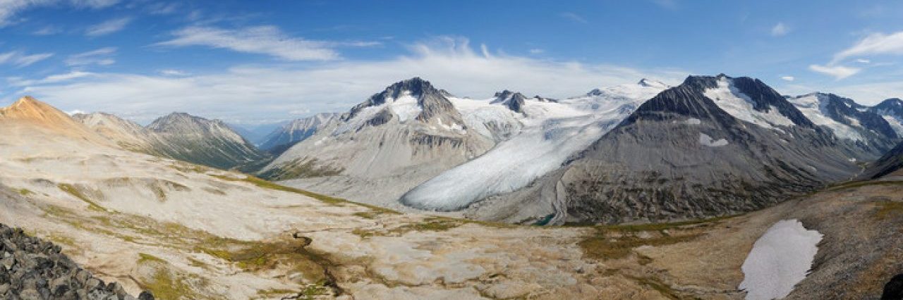
Around the corner lay the famous Seymour Icecap. Well, OK it’s just a small permanent snowfield in the shadow of Second Peak, so it’s an ironic nickname. The boulder field around it squeaked with a pika or two. Third Peak lay up above us, and we began the ascent over a large smooth slab. It’s not difficult to climb, or descend as there are a few cracks and steps that offer a couple of routes, but it does require a little bit of care, especially if wet. This is one area which is treacherous in the winter as a slip here could result in a slide most of the way down into the Seymour River valley.

Once again the roughness of the terrain surprised us. Or it did me at any rate. We had to haul ourselves over or around a few large boulders and pay attention to the trail markers, as they really did mark the best route. It would be easy to end up on the wrong route and get into a little bit of trouble. A few more minutes of hauling ourselves uphill and we reached our goal: Mount Seymour.
The last time we were here it was cloudy, and the clouds only began to lift as we reached the summit. But we had no views to speak of, and only a hint of the drop down to Runner Peak. So I was really happy to get to the summit, and explore the sheer northern face of Mount Seymour. A couple of tree-and-heather ledges gave a nice vantage point looking down. Maria went up to the edge above me and I snapped a couple of photos of her next to the steep north-facing cliffs. Our view to the north wasn’t as expansive as I’d hoped as clouds still lingered over the distant peaks of Mamquam and Garibaldi. (Both can actually be seen from First Peak, at least in winter.)

We roamed around the summit a bit, looking for a good spot to enjoy the second half of lunch. We found a rock carving of a drum kit! I’d seen it in a Club Tread trip report, but didn’t expect it to be in such an obvious place. I found patches of bright red berry leaves to photograph, some brightly backlit by the afternoon sun. We just revelled in the autumn glory.
Time to head back down the trail, as it was getting late and we’d run out of daylight if we weren’t careful. It’s always so tempting to hang around, especially as mountain sunsets can be glorious. We set off again, and within a matter of minutes found ourselves at the top of a small angled cliff. It wasn’t too high, and was probably scramblable (is that a word?) but I didn’t fancy it. Maria found a way to slide down it while I went back and found those pesky trail markers.
Back on track and we retraced our steps back to Second Peak, passed it by again and headed back to First Peak. We paused to look at a tree we’d admired on one of our last snowshoe trips and realized just how deep the snow was at that time! It’s always fun to compare. As we reached First Peak a wave of laziness came over us and we figured that we’d seen it enough times and didn’t need to bother hauling ourselves up there again. I’m sure we’ll see plenty of it this winter :-)

Half an hour later we were back at Brockton Point, where we re-joined the section of ski run. Our ears pricked up when we heard what sounded like dogs barking and yelping down below us. The barking was really urgent, as if the dogs were either in trouble or fending off something. Something large, black and furry, perhaps? A few minutes later we encountered the owners and their three dogs (none on a leash) and exchanged a few words with them about the barking. Sure enough it was their dogs and right again, they were barking at a black bear. Great, I thought. I don’t need to encounter an angry bear on the way down. Normally a bear would be chased off by three aggressive dogs, but there’s always the risk that this one time that wouldn’t happen and the bear would end up in a state of irritation, and of course that would be the time we’d encounter such a bear….
But our descent was uneventful and less than half an hour later we were back at the car, with one last photo call before we headed home: the afternoon sunshine on Mt Baker was gorgeous and we stopped off a couple of times to take its picture. Undoubtedly one of the nicest views of Baker we’ve had in a while.

Suitably satisfied with our day, we headed home.
Distance: 9 km
Elevation gain: 450 m
Photos on Flickr
