
Five years ago we did this hike in the rain, which seems quite remarkable given all the warnings associated with this trails. I vowed that I would repeat this hike only on a sunny day, as I’d seen photos of a rainbow at the main falls and decided I wanted to see that for myself. Andrew and Merewyn were happy with my choice and it was indeed a beautiful sunny day that we set out for Squamish. Driving up the Squamish Valley road, we were struck again by how imposing the Tantalus Range is at river level. A number of unnamed waterfalls cascaded down their slopes, falls which would, undoubtedly, have been celebrated had they been more accessible (and less seasonal).
We missed the trailhead (I was going by memory :-) and ended up turning round a km or so down the road, back-tracking to the bridge where we’d seen a couple of cars parked. We were the third car there; as a sign of how busy it was going to be, a fourth car pulled up as we laced up our boots. Crossing the bridge over High Falls Creek, we picked up the trail marked by a large circular disk with the trail name written on it. The trail led us along a flat valley bottom for ten minutes before ending abruptly in a steep gully – I didn’t remember that at all! Climbing it was easy, though, and it brought us out onto the rock and the first set of chains. Andrew went first, and scrambled up without using the chain. Merewyn next, then me. I managed to avoid using the chains too, though I made the mistake of looking over my shoulder at the already-precipitous drop into the gorge.


Nothing to do but keep heading up. I must admit that the going is straightforward and not difficult. It’s quite easy to get up the steepest sections without resorting to the chains, though it depends on how dirty you want your hands and knees to get. In a couple of places the trail ventured very close to the cliff edge, and we got our first indication of how far below us the creek was. The views weren’t always straight up and down though. Here and there we caught glimpses of the waterfalls across the valley.
After about an hour of uphill work, we reached the main viewpoint over High Falls where we could see the waterfall cascading out from a gap in the rocks, hitting more rock and then dropping all the way into the canyon. We threw in a stone and counted how long it took to reach the bottom (which we could plainly see with minimal risk). About five seconds – a quick calculation turned that into over 100 m deep. Whoa – we had a football-pitch of air between us and the creek. That’s a deep canyon.


We stayed here for a while, though I was disappointed to see there was no rainbow: there’s only so many waterfall photos you can take. But just as we were gearing up to leave, the sun came round a little more and suddenly we had a rainbow in the spray, which duly prompted another round of photo-taking. We eventually dragged ourselves away from the view and continued climbing upwards. The terrain began to level off somewhat, and we were treated to a good view of the upper falls, not visible from the main viewpoint.
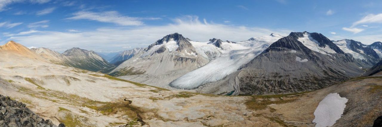
At last, somewhere to stop and rest! The last time I did this hike it was raining so we didn’t linger, but with today’s warm sunshine, sitting down and basking felt like the right thing to do. The scent of the pines filled the air, and I filled my nose with as much as I could take. I wish I could bottle that. Probably wouldn’t smell the same at home though ;-) We lounged for a few minutes, taking in the sight of the Tantalus and Squamish Valley peaks before us. Sigurd Peak had some particularly impressive cornices.


Moving on, we followed the now-pleasant trail uphill through wonderfully aromatic pine and fir forest. We came to the side-trail down to another view of the creek and of course had to follow it to get all those views. Here the creek is entirely in the shade, so I was able to get some longer exposure photos to smooth out the water flow. It’s amazing how narrow the canyon is here. It felt like we could reach across and touch the lichen on the opposite wall (not that we were tempted to actually try that!). We rejoined the trail once more and continued upwards. By now I was wondering about a lunch spot, but we decided to just keep going, and stop if something caught our eye.
Well something did catch our eye: a grouse. It raised its tail and walked slowly away from Andrew (who was in front). Andrew went for an action shot, raised his camera and ran at the grouse, which simply walked away a bit faster until Andrew was almost within grabbing distance before taking off in that noisy way they do and weaving its way into a nearby tree. I captured the evidence… and Andrew didn’t get his grouse photo :-)
The trail began to level off somewhat, and we entered different forest. Cedars and hemlocks now joined the Douglas firs, and the pines were left behind. We came to a messy junction, orange flagging tape all over the place, where a trail veered off to the left towards a clearcut. That seemed to be the way out for the shorter version, but my memory was playing tricks on me. I didn’t remember walking out through a clearcut, plus we hadn’t passed a section of trail I vividly remember, as I took a photo of Maria just as she passed behind a tree.
We continued on the right-hand fork, over an exploded fallen tree, passing a moss garden filled with yellow violets, kept moist by a trickle of a creek. And then we reached the point I remembered. I thought that we still had the left/right choice ahead of us, so we carried on, but after another 20 minutes or so I began to wonder. I didn’t recognize the trail any more: we were high above the creek in open forest again, the trail mostly following the contour of the terrain and rising only gently. Was I misremembering? Had we backtracked last time on account of the rain? That seems unlikely given that we continued walking up the road once we exited the trail. I found myself completely unable to reconcile my memory of the previous trip with what I was seeing today. Well, what else can you do in that situation but shrug and keep going? Reality was right there in front of me! :-)
I stopped worrying about the previous trip and let myself enjoy where I was. On the other hand, there were no lunch spots recommending themselves to us, and we were tiring. We pushed on and after gaining a little more height and passing through some berry bushes which would be heavenly-laden later in the year we emerged at the infamous rock slide. We left the shade of the trees behind and spent the next ten minutes being baked by the hot sun and rocks. Just a little further and we reached the logging road. I was happy: I had done the trail I wanted to do.


Of course, out on the road there was no shade, nowhere to sit either so we began our trudge downhill. We stopped at the corner (with a rock sprayed “Reefer Ridge”) where a bench used to be to admire the fantastic views of Cloudburst to our left and the Sigurd Peak area in front of us. And the hundreds of shotguns shells all around our feet. The bench was presumably turned to firewood long ago. Well nothing to do but keep walking until we spied a suitable tree offering some much-needed shade. We off-loaded our packs and found comfortable spots to sit and have some lunch at last!
It was time to move on again and we set off along the road. We stopped briefly to admire a hummingbird dart around the tree tops before getting into our stride for the long walk back to the car. The last time I did this the views were minimal, but I remembered seeing some nice flowers. Today we had endless views and I have to say that it really doesn’t matter that you’re trudging down a dirt road – the view of the meandering Squamish River and up the Squamish Valley is tremendous. The time passed quite quickly. We found a few flowers to photograph, but not as many as I remembered. The flowering dogwoods were past it which I was a little disappointed about – I was hoping for some nice ones here.


Eventually we turned the corner and only now did the road begin to drag. The last 3 km seemed to take a long time, but in reality it was perhaps only 45 minutes. Back at the car and into Squamish for a huge helping of gelato at Carina Gelato! Then a quick stop at Shannon Falls to join the hordes of tourists falling over themselves to take photos of each other in front of the falls. Then an unexpected stop at Porteau Cove: as we drove out of Britannia Beach, we passed the Rocky Mountaineer heading back to Vancouver from Whistler. The railway line goes right through Porteau Cove provincial park and I had a major train-nerd moment and decided to call in and wait for it. Camera in hand, I stood by the crossing waiting for the train. It came around the corner, under the bluffs and was soon thundering by as I snapped a dozen shots. Passengers in the viewing carriage waved, and I waved back. What a great way to end a fabulous day of hiking!

Distance: 12 km
Elevation gain: 640 m
Photos on Flickr
