
Lorna Lake to Deer Pass: 15.5 km, +970 m, -580 m, 10 h 15 m
I stirred around 6 am after another quiet night to be greeted by the high-pitched squeaky calls of kinglets in the trees above us, soon joined by a chattering Douglas squirrel – Mother nature’s alarm clock. The clear skies meant a cooler night, which I’d felt at times. It was a joy to come round in this quiet place, with not even a distant creek to provide any background noise, and not a breath of wind. I dozed until around 7 am when the sun peeked over the ridge and lit up the forest around us, prompting me to begin packing away my gear. I nudged Maria awake so she could make a start on her packing too, and we stuffed our gear into our backpacks before venturing out into the morning to greet the others.
We collected our food bags and made our way over to the end of the lake just as the sun rose high enough to bathe it in the first warming rays of the day. The lake was a perfect mirror, reflecting the mountains beautifully. We boiled water for tea, coffee, and oatmeal and savoured the uplifting sunshine of a new day in the mountains. Another “pinch me” moment – sitting by the lake with such a perfect scene was utterly breathtaking, and I found it hard to believe I was really here.


A breeze picked up enough to riffle the surface of the lake, destroying the reflection but now allowing that intense colour to show. It felt far too good a spot to leave. But leave we must, and we finished packing up our backpacks and hauled ourselves onto the trail for about 10:30 am. We set off through sandy pine forest that smelled heavenly in the morning sun while, at our feet, stonecrop and lupine were working overtime on flower duty.
We came to a signpost and turned onto the trail that led towards Lorna Pass. Through more sparse pine forest we walked, passing a couple of small ponds (one complete with a generous supply of large tadpoles) amid gently lumpy terrain. We were relieved to see a bridge over Big Creek, even if it was a remarkably saggy and bouncy twin-log bridge. I couldn’t help but wonder how this bridge survived the spring runoff as it wasn’t very high. On the flip side, I was pleased to note that the creek crossing looked manageable – at least at this water level – should the bridge not survive in future. (Prescient thoughts, as it turned out – but that’s getting ahead of myself.)


Now we began to climb through a mix of lodgepole and whitebark pine forest, the loose dirt trail leading steeply uphill, painfully so at times given our heavy packs. (Alas this would not be the last time we felt this way today!) It was a grind, for sure, and we plodded upwards, thankful for gaps in the trees that offered reasons to stop and admire the views behind us. We were less than thankful for the mosquitoes that found us….
Within only half an hour (which felt like a very long half hour) we found ourselves above the trees and stopped to take in the view of the Big Creek valley. And what a huge valley! We could see over to the Sluice Creek drainage and the ridge we hiked yesterday, with new views downstream towards the Cluckata Ridge and, more distantly, the Dil Dil Plateau. Big Creek seemed to be well name: it was certainly big country!


We came alongside and then crossed a tumbling little creek lined with flowers and entered a narrowing valley. The path climbed up away from the rich paintbrush-filled meadows of the creek across flower-covered slopes dominated by sulphur buckwheat with a supporting cast of strawberry (including some berries), thistle, and arnica. A clear edge to the sulphur buckwheat marked an obvious spring-line on the hillside. The uphill continued ever on, levelling off slightly over compacted scree before the final climb up to Lorna Pass where a small sign informed us we were entering the South Chilcotin Mountains provincial park. With one last look behind us, we crested the pass to enter the Tyaughton Creek headwaters where the wind promptly hit us with full force and we hurried a short distance into the valley to find some shelter and to grab a snack.


It was a fine place to draw breath given the expansive view before us – a wide, verdant valley carpeted with grassy meadows on the south-facing slopes. and the first trickle of water that would make its way down to become Tyaughton Creek. And grasshoppers, so many grasshoppers! We lounged around in the sun for a good half-hour before shouldering our packs again and beginning the descent on a delightfully easy trail.
The views unfolded before us as we went, with flower-filled meadows (a little past their best after the scorching heat dome of a month ago), inviting tarns, and more craggy mountain ridges. Thousands of moptops lined our path, accompanied by the wispy seed heads of three-flowered avens (also known as prairie smoke), patches of low willows, and colourful red paintbrush and fireweed contrasting against the expanse of green. We passed a few marmot burrows and were wondering where the marmots were only to be alerted to their presence by a piercing whistle about 50 metres away. A pair of sentries standing upright next to another burrow kept a close eye on us as we walked past.


Within half-an-hour we reached the treeline again, sparse pine forest on steep slopes connected by pocket meadows full of glorious yellow balsamroot – possibly the signature flower of the South Chilcotin mountains. The descent had been easy and gentle so far, but took a turn for the steeper for a while before resuming its gentle course, once again in verdant meadows, and levelling off as we neared the valley bottom. A pair of woodpeckers caught our ear as they hammered on a fallen log, while later a grouse exploded into a nearby tree, frightening the life out of us. Only then did we notice the chicks scurrying for cover at the base of the tree. The only other wildlife we encountered was an increasing number of hungry mosquitoes
An unmarked trail joined us from the left, presumably the way up to Elbow Pass, and a short distance later we came to a small meadow that was clearly used for camping. Here, a couple of side trails led down towards the creek and we weren’t sure which one to follow. We picked one and followed it for only a short distance before it led to a dead end at an unappealing mud-pit by the creek – clearly this is where the horses walked. We retraced our steps and took a different side trail to a different ford on the creek which we knew couldn’t be right as we weren’t due to cross it yet. Nonetheless, this spot had shade to escape the hot sun and enough of a gravel bank for us to sit and eat lunch.


We enjoyed a leisurely lunch hour listening to the sound of the creek, admiring the array of flowers – notably white bog orchid, fringed grass-of-Parnassus, and pipssisewa – snoozing, and refreshing our faces and feet in the frigid water. We topped up our water bladders and found that mine appeared to be leaking, so I strapped it to the outside of my pack so as not to risk soaking anything inside. Exploring upstream we found a well-hidden bridge over the creek that led to – where? We’re not exactly sure. Perhaps this was the way to join the trail up the Lizard Creek valley? We couldn’t quite work it out.
All too soon it was time to move on and we rejoined the trail, taking the third and final (left) side-trail option to continue on down the valley. Almost immediately we were faced with another creek – I think it was Manson Creek, milky with sediment from high above – and crossed on a pair of very slippery small logs that had once formed a bridge but had been washed off its footings into the water. We made it without getting wet and picked up the trail again, which – thankfully – seemed to be heading in the right direction. The trail started out easy, then deteriorated into a few boggy sections, before climbing a bit and levelling off again, all the while a mixture of forest and meadow. Seemingly out of nowhere, the open meadow we were walking through was joined by a vast screen slope that swept down from the mountains above. It was quite surreal how the rocks ended abruptly in a green meadow!


A few minutes later we passed through a gate at the edge of a horse camp and entered some wonderfully shady forest interspersed with large sunny meadows, rich in paintbrush, arnica, and cinquefoil, which set the scene for the next little while. It was thoroughly enjoyable hiking. About an hour after leaving our lunch spot, we came to a vast grassy meadow, the biggest we’ve seen and paused to take in the view. Here was where we would turn off to cross Tyaughton Creek and begin the second – and more strenuous – climb of the day up to Deer Pass. Ahead of us we could see someone on horseback, and we stepped off to the side to stay of their way. The rider was with a pack horse and she stopped to chat a bit about life as a camp host and guide in these mountains – for her there was no other life she could imagine, but we wondered how many more people would follow in her footsteps (or hoof-prints) – plus offer some info about the way up to the pass. She was on her way up to the horse camp we’d passed earlier in preparation for the arrival of some guests.
We bade her farewell and took the signposted turn towards Deer Pass, soon reaching the creek where we dropped our packs to assess the crossing. The creek was about 10 metres wide here and we crossed just upstream of a small island that divided the creek into two sections. I unlaced my boots and pulled on my creek shoes, venturing into the cold water to test the depth and current. Thankfully the water was barely knee-deep, even on me, and I was relieved that the crossing was going to be about as easy as it could possibly be. The four of us took turns getting our packs over to the other bank and were content to wade back and forth in the refreshingly-cold water for a few minutes before emptying the gravel from our shoes (I was surprised that so much got in!) and drying off our feet in the hot afternoon sun.


We were feeling relaxed and lazy and it was with the greatest reluctance that we began the climb, moving a short distance into the shade to top up with a snack and examine the map to see what lay ahead. Behind us we could see up to a ruddy peak that towered over the valley, its triangular summit piercing the azure sky, and yet unnamed on the map. Time was passing – it was now almost 5 pm – and we couldn’t put off the big climb any longer: having hiked 10 km we now needed to hike the equivalent of the Chief – another 5 km and 650 m of elevation gain – all with our packs at their heaviest. Whose idea was this? Oh yeah, mine… 😬
There was nothing to do but psych ourselves up to the challenge and take our first steps uphill, initially following a cool rushing creek, then winding away into the forest. Despite being in the trees there were plenty of open areas, pocket meadows full of aromatic lupines, balsamroot, paintbrush, and arnica, with a few glacier lily pods here and there. And bugs – the mosquitoes found us again (especially me), although they only were a minor nuisance at worst.


Forest, meadows, forest, meadows – rinse and repeat. We crossed a few small creeks, each with short, steep descents and climbs on either side to drag at our tired legs, and continued ever upwards. We had plenty of birds keep us company – hermit thrushes sang in the treetops, a wren powered out its trilling song, we even spotted a ruby-crowned kinglet up close. We had three close grouse encounters, one of which sat in the middle of the trail and refused to move even as we approached. In the end, we walked around it! I managed to snap a picture or two and I wondered if it was sheltering its brood (something we have seen before). For another encounter, we didn’t see the multiple grouse until one of the chicks flew up into a tree while the mother sat still on the ground and clucked softly as we passed. I always enjoy these moments, getting to see wildlife in its natural habitat and I try my best not to disturb them.


It was a tough old push up towards the pass and, even though we had making steady progress, a quick check of the GPS told me what I didn’t want to acknowledge – that we still had some distance and elevation to go. After a long hour-and-three-quarters in the trees the views began to open up and we could finally get to see some reward for our efforts. We came to a spot that looked like a great camp site with a clear view over to the orange peaks on the north side of Tyaughton Creek, including the pyramidal summit we’d admired down in the valley and over to Mount Cunningham and Castle Peak, where we’d explored the previous year. We paused for a few minutes to catch our breath and to pull on a warm layer as the chill of the subalpine air made the warmth of the valley sun a distant memory.
Having cleared the trees we could now see the way ahead, and I must admit it looked daunting. The pass still looked far away and there was clearly some elevation left to gain. But the view was spectacular – moptop-filled meadows stretched away ahead of us, while the head of the valley was marked by a huge jagged mountain lit up beautifully in the now early-evening sun. I spotted some mountain larkspur waving in the breeze – a pleasant surprise! We plodded on with tired legs and heavy packs, still gaining elevation and willing the pass ever closer. Deer tracks peppered the dirt on the trail, mostly heading in the same direction as us, while a lone set of bear tracks pointed downhill.


The exertion of the day was really beginning to tell on us and our pace slowed, forcing us to take frequent breaks to manage our energy levels. On the other hand you could say we were maximizing our time admiring the views before and behind us. It was all eye-popping stuff and it was good to remind ourselves to take a moment out of our hard work to look up from our feet and absorb our surroundings.
I tried to read the terrain ahead and work out where the trail to the pass went – the headwall looked steep and intimidating, and it wasn’t at all obvious how we’d make it up there safely. But I knew there was a way, so I tried not to worry about it and to just enjoy my immediate surroundings. Now high in the alpine, we entered familiar terrain of hard-packed dirt riven with sharp gullies. A few fresh western anemone flowers lined the trickling creeks therein but I was too tired to get down on my hands and knees to get a closer view.


We crossed one such gully on precarious eroded and polished rocks that offered little or no grip. I remembered too late the advice offered by the other campers at Lorna Lake from yesterday to continue uphill on an alternative trail – an alternative trail I’d even seen and wondered to myself, “where does that go?”. We’ll know next time I guess. We made it across okay but it was quite nerve-wracking, so much so that we stopped for a break to regain a little composure.
Movement caught my eye and a marmot materialized on an outcrop about 10 metres down the slope, outlined against the green meadows below and surveying its vast domain beyond. It was surprisingly unfazed by our presence and quickly settled down on the rock again. A few more marmots entertained us as they scampered over the nearby slopes. We hauled on our packs again and plodded inexorably onwards, our hearts sinking as we reached another gully, but to our relief a zig-zagging path led us up to an easier crossing.


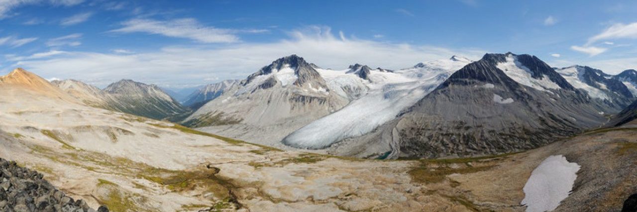
Could it be? Was the pass really close now? We rounded a bend in the trail and could see the final few hundred metres to the pass laid out before us, a welcome easy path to follow. Gusts of wind threatened to disperse any warmth we had accumulated and we stopped in a sheltered area just before the pass to regroup and gather our strength for the final push. A few minutes later we crested the pass in the last of the day’s sunshine and were hit by the full force of the wind. And what a view greeted us, though we had little time to savour it as we just wanted to get out of the wind and find a place to camp.


We descended from the pass over the tundra and past the tarn – which was bigger than I expected – making our way over to some silty flats to set up our tents. It felt so good to drop the packs for the last time and we quickly pulled out the tent and proceeded to do battle with it and the wind. We managed to get it staked and tied, immediately crawling inside to arrange our sleeping gear and put on some warmer layers. It felt so warm out of the wind inside the tent, and we were tempted to just lie down for the night. But we needed food – badly! – so the four of us reconvened in a semi-sheltered hollow near the tarn to make some very well-earned dinner.
Oh that hot food tasted so good! We chatted about the trials and tribulations of the day and how we really shouldn’t make the first day of a backpacking trip the toughest. That’s twice now… Perhaps tomorrow will be a rest day? At least, compared with today! As the light of the day faded we used the rock caches to weigh down our Ursacks – though it wouldn’t stop a bear, it would be enough to keep the marmots out at least which are more common up here than bears. Or so we hoped.


At that, it was time to retire to our tents for some rest. I wasn’t sure how well we’d sleep given the near-constant buffeting of the tent by the wind, but I doubted that it would keep me awake for long… Crawling into my sleeping bag felt so good and I spent only a few minutes writing some notes before my eyes began to close. We turned off the light and settled down for the night.
I tell you, it felt so good to not be hiking!


Great photos as always! I’ve never heard of the common name “moptop” but I love it! So perfect! I have very fond memories of deer pass, my knees on the downhill not so much. . .
I think it’s a great name for them 😀
We didn’t descend from Deer Pass on this trip (hiking the Mount Sheba ridge instead) but I can imagine it. Our final descent a few days later was excruciating though…