
Opinion
Well, this might just be a summer of surprises – this hike was much more enjoyable than expected. I was prepared for a boring little grunt up the slope (a la Grouse Grind) but the trail was varied and interesting, and yielded great views pretty quickly that never let up. Sure, it was definitely steep, but it never felt unmanageably so. Then there were the stunning views from the summit, which was not as airy and scary as I expected.
But there is a good reason Yak Peak is in the Scrambles book: you will need your hands in many places along the way, sometimes grabbing branches, other times handholds on the rock, and others just for balance. The rock is slick in places, and would be tricky if wet or icy. In some places the granite has weathered to gravel and care is needed not to slide on those. I didn’t take poles, and I think they would have been more of a hindrance than a help for most of the hike. They may have been useful on the lowest and uppermost stretches though, where we were actually hiking.
A big thank-you to Tamara for organizing this hike through Wanderung – I’m really glad I went.
Fact
Parking is easy at the Zopkios brake check. Just watch for incoming trucks as you exit the underpass if coming from the west. Walking alongside the highway isn’t fun, but it’s a pleasant warm-up. Ear plugs might be useful for this section as the truck traffic is loud. The turn-off away from the highway is marked by an old traffic cone. The only mud on the trail is encountered in the next 50 m.
Up through the forest, the trail is well-defined and flagged. Somehow we managed to get off-trail and ended up bushwhacking up a creek bed through alder before finding our way back. On our descent we looked and looked and could not see where we went wrong as the way down was glaringly obvious.
Beyond the forest, the route is well flagged and marked with cairns in places (usually with flagging attached) until reaching the alpine where there is a trail once more. Near the summit, the snowfield mentioned in Matt Gunn’s description is small enough to avoid – an ice axe is definitely not needed at this time. We visited the subsummit of Yak (which we dubbed the Yaklet) which has a great view straight down the south face of Yak, before heading over the main summit.
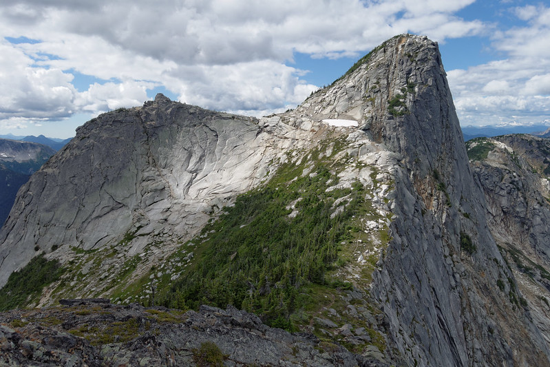
Despite appearances from afar, Yak’s summit area is large and encourages lounging around. It is possible to dangle your feet over the sheer north face which sounds (and looks) terrifying but in actual fact, you’re only sitting above wide ledge about 10-m below your feet. For a great view back towards Yak, head over towards Nak Peak but only as far as the small bump along the way (which we called the Naklet – see a pattern here? :-) Here you’ll get the full, spectacular vertical cliff of Yak’s north face.
We encountered marmots, pikas, and (I think) golden-mantled ground squirrels (hard to tell as it was quite distant), plus a small falcon rode the thermal up and over our heads as we sat on the edge of Yak Peak. I heard nuthatches in the forest and the occasional robin. Flower wise things are pretty much over – a few stragglers here and there, Queen’s cup is now sprouting its blue bead, rosy twistedstalk has red berries – but berry season is very much underway with many tasty little blueberries to distract you on your ascent!
Distance: 7.8 km
Elevation gain: 960 m
Story
I’d put off hiking Yak Peak for years on account of its stats: 6 km return, 850-ish metres elevation gain. Hey, I know a “hike” just like that – it’s called the Grouse Grind and I don’t have to drive for 2 hours to get there! And so with those thoughts in mind, and despite its obvious aesthetic attraction, the trail up to Yak went unheeded. Plenty of folks seemed to enjoy it, though.
When I saw Tamara’s call-out for a driver, I stopped and thought a little harder. Perhaps I could go do this and report back to Maria with my findings (she’s not a fan of short, steep hikes). So I replied and lo and behold, they still needed a driver and I’d signed up just in time. By 7:10 am the following morning, we were pulling away from the Safeway parking lot and headed for the Coquihalla.
A smooth two hours later (though sadly not for traffic headed west, where there’d been a fatal crash on Hwy 1) and we were tying our bootlaces ready to go. We walked back up the off-ramp that leads into the Zopkios brake check, past decelerating trucks, and followed the gravel path alongside the highway. For about fifteen minutes we walked (covering a kilometre or so), barely able to exchange a few words on account of the noisy, speeding traffic. But then we reached the turnoff point – an old traffic cone and some flagging tape – and we dropped down the embankment, over a small creek and a muddy meadow before entering the forest.
Instantly the hush descended on us; the sound of the highway now muffled and we could hear ourselves think once again. A fairly well-defined trailbed led the way uphill through that lovely mid-elevation forest we like so much. Queen’s Cup leaves (and a few blue beads), bunchberry, and rosy twistedstalk covered the forest floor. We picked our way over a few fallen trees, and over a couple of large rocks and plodded up the slope.
Soon we found ourselves pushing our way through bushes and some alder as we followed the trail – no wait, that’s a creek bed. Where’s the trail? Somehow we’d wandered off the trail and ended up bushwhacking our way along the edge of the trees. I checked the mapping app on my phone – the Open Streetmap layer had trails marked – and noted that we were 30-50 m off trail. Oops. We found our way back and were soon on our way up again, this time on the trail!

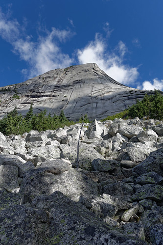
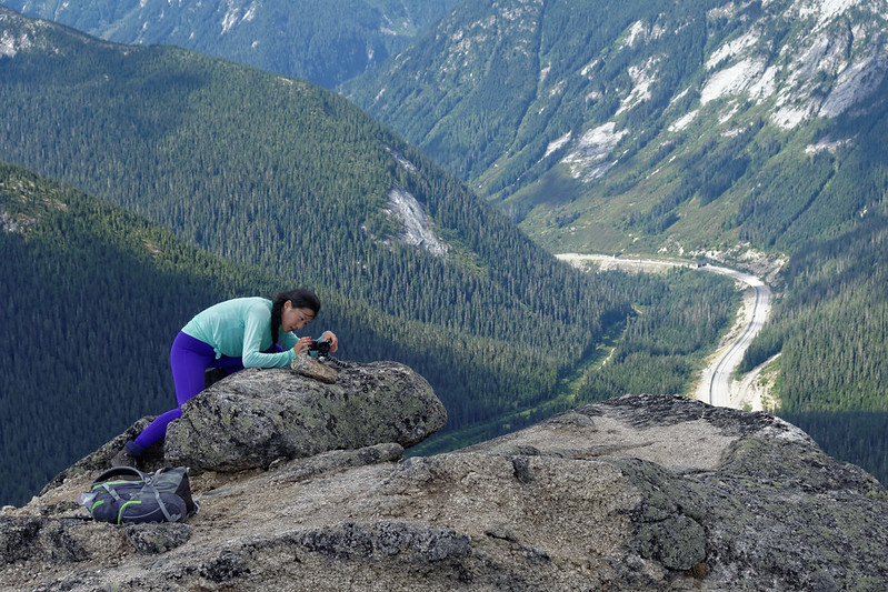
About 40 minutes later we emerged from the trees onto a boulder field, and caught our first view of the day. Looking west, we could see down to the highway; above us lay the sub-summit of Yak Peak (though we didn’t know that at the time). We picked our way up through the boulder field, following flagged cairns, and reached the base of the big open expanse of granite that defines the appearance of Yak. We turned right along the edge of the rock, before turning upslope once more, sometimes on the rock, sometimes in the shrubs. Flagging kept us on track.
The trail was fun and easy to follow. In places we needed our hands to grab hold of bushes or trees (veggie belays) for stability, as we crossed a couple of slabs and then up the slope once more. A fixed rope was very helpful at one point as the rock had been worn smooth. Up and more up, zig-zagging back and forth up a blueberry-filled gully. And those blueberries were delicious! Tart, but full of flavour.
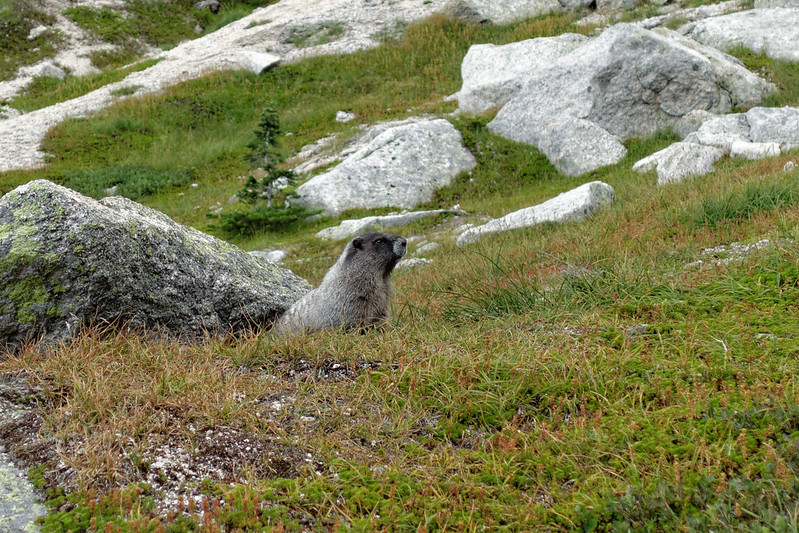
After about 45 minutes of solid uphill, we entered a heathery subalpine bowl, complete with whistling marmot. The rodent was quite obliging and stayed put for a short photo session before scurrying back underground. By now the clouds had really rolled in and our glorious sunny day had vanished. At this elevation, the grey skies made it feel quite uninviting, and we wondered if we get rain. But gaps remained, and the sun occasionally broke through to light up part of the surrounding terrain.
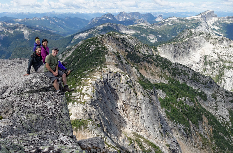
We reached the snow patch mentioned in the Scrambles book and we were pleased to find that Gary and I had brought our ice axes for no reason :-) This late in the season, the snow patch was small and easy to walk around on firm ground. At the col, we wondered whether to push straight up to Yak or visit the nearby sub-summit, which we quickly dubbed the Yaklet (in keeping with Nub Peak and the Nublet in the Mt Assiniboine area – as it happens, Gary shares our love of the Rockies and has done a fair bit of hiking there). It was well worth the visit: a small summit area with a fun little rock to perch on and a great view straight down the face of Yak to the highway below. We set up a quick group photo, perched on the rock, Xiru having to run and scale the rock within the 10-second timer! It took a couple of attempts (and a scraped knee) but we got the shot :-)
We retraced our steps and made the final 50-m ascent up to the summit of Yak. A trail was evident the whole way up, with just a bit of flagging to guide us through some krummholz and rocks. And what a gorgeous summit it was! Much broader than it looks from afar, with plenty of space (for even a coach load – not that I’m suggesting that number of people…!) to lounge around, explore, take photos, and generally enjoy being up on a 2000+ metre peak.
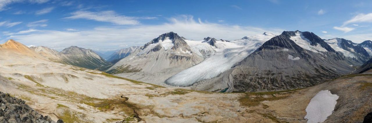
Tamara scouted out a great lunch spot, out of the wind and with a safe edge for us to dangle our feet over. And so we relaxed. The views were stunning – before us lay a huge drop into the valley that ultimately leads to Falls Lake. Zoa Peak (mostly in shadow) in one direction, Zupjok, Llama, Alpaca, Vicuna, and Guanaco in the other, with others more distant such as the peaks of the Anderson River group. Behind us lay Needle Peak (where another Wanderung group was hiking) and the Flatiron, with the Illal/Coquihalla area off a bit further east. And then so many more distant peaks all around.

We hung out on the summit for almost an hour before we decided that we really ought to begin our descent. Retracing our steps, I voiced the idea of heading over towards Nak. We looked at the map, discussed it a bit and figured that we could at least head in that direction and see how much time we have. The first goal was a small bump after which we’d have to lose elevation. We picked our way over to a trail leading up through trees and rocks (duh), past a squeaky pika, and temporarily displacing a marmot slouching on a comfy rock.
On reaching the bump (which we called – surprise! – the Naklet), we realized that this was as far as we needed to go. The view back to Yak revealed the full height of the sheer north face in spectacular fashion. It was such an incredible sight, we stopped and admired it for some time (taking the requisite number of photos too) before finally admitting that it really was time to make our way back to the car.
And so we began the painstaking descent back through the bowl and down, down, down the slope. At least we had the views to look at this time, now bathed in bright sunshine. To my surprise, some of the slab sections were actually easier to descend – being able to plant my boot sole flat, rather than just on my toes meant I had lots of grip even though the rock was quite smooth. As we descended through the forest, we tried really hard to spot where we’d gone off trail in the morning, but couldn’t see it. I kept an eye on the GPS track, but the accuracy wasn’t high enough in the trees. Weird. I guess we’ll never know!
Two hours after leaving the Naklet we were back at the car and ready to head to the Blue Moose for afternoon coffee. We’d all really enjoyed the hike, and had gelled quite well as a group with many common experiences to chat about. Normally I try and get a feel for how much the group likes Wanderung, but it didn’t seem necessary – we all had a great time. And so Yak Peak goes onto my list of surprisingly nice hikes, and it reignited my thoughts about exploring more of the Coquihalla area with all those inviting ridgelines….

